|
Today's Storm Reports (20240425 1200 UTC - 20240426 1159 UTC) (Print Version)
|
< 240424 Reports
240425 Reports >
|
| Note: All Reports Are Considered Preliminary |
|
|
|
|
| Tornado Reports (CSV) (Raw Tornado CSV)(?) |
|---|
Time | | Location | County | State | Lat | Lon | Comments |
| 1707 | | 1 NE Herriman | Salt Lake | UT | 4053 | 11201 | [Landspout] A brief landspout was reported via numerous photos and videos. One photo in particular appears to confirm the circulation briefly touched the ground by kic (SLC) |
| 2115 | | 11 E Yoder | Goshen | WY | 4192 | 10409 | Numerous reports of a funnel cloud with occasional ground circulation between Huntley and Lyman. Separate event from earlier landspout. (CYS) |
| 2145 | | 10 SSW Bird City | Cheyenne | KS | 3961 | 10159 | Media reported a tornado east of HWY 27 & B. Location estimated based on radar. It lasted about 2-3 minutes. (GLD) |
| Hail Reports (CSV) (Raw Hail CSV)(?) |
|---|
Time | Size | Location | County | State | Lat | Lon | Comments |
| 1637 | 100 | 5 SSE Milford | Geary | KS | 3910 | 9688 | Heavy rain falling. (TOP) |
| 1752 | 100 | 4 ESE Council Grove | Morris | KS | 3865 | 9643 | (TOP) |
| 2058 | 175 | 5 SE Wind Cave Visitors | Custer | SD | 4351 | 10341 | (UNR) |
| 2058 | 175 | 4 SE Wind Cave Visitors | Custer | SD | 4352 | 10341 | (UNR) |
| 2109 | 100 | 2 NW Buffalo Gap | Custer | SD | 4352 | 10334 | Drifts of hail (UNR) |
| 2119 | 175 | 9 E Yoder | Goshen | WY | 4194 | 10412 | (CYS) |
| 2120 | 100 | 14 SSE Bird City | Rawlins | KS | 3957 | 10140 | (GLD) |
| 2145 | 100 | 8 E Yoder | Goshen | WY | 4194 | 10414 | (CYS) |
| 2205 | 100 | 6 N Parks | Dundy | NE | 4012 | 10174 | The public reported 1 inch diameter hail 5N 2E of Parks. The hail is ongoing. (GLD) |
| 2210 | 150 | 2 NNW Blakeman | Rawlins | KS | 3984 | 10113 | Trained spotter reports 1 3/8 inch diameter hail. (GLD) |
| Wind Reports (CSV) (Raw Wind CSV)(?) |
|---|
Time | Speed | Location | County | State | Lat | Lon | Comments |
| 1342 | UNK | 2 SSW Sherwood Estates | Saline | AR | 3459 | 9254 | mPing report of large tree limbs blown down and shingles blown off of a roof. (LZK) |
| 1350 | UNK | 3 WSW Little Rock | Pulaski | AR | 3473 | 9234 | A large tree was downed at the Arkansas Cooperative Extension. (LZK) |
| 2037 | 58 | 11 W Hot Springs | Fall River | SD | 4343 | 10369 | (UNR) |
| 2058 | 60 | 5 SE Wind Cave Visitors | Custer | SD | 4351 | 10341 | (UNR) |
| 2058 | 60 | 4 SE Wind Cave Visitors | Custer | SD | 4352 | 10341 | (UNR) |
|
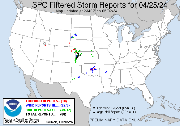
| Filtered Tornado Reports (CSV) (Raw Tornado CSV)(?) |
|---|
Time | | Location | County | State | Lat | Lon | Comments |
| 1707 | | 1 NE Herriman | Salt Lake | UT | 4053 | 11201 | [Landspout] A brief landspout was reported via numerous photos and videos. One photo in particular appears to confirm the circulation briefly touched the ground by kic (SLC) |
| 2115 | | 11 E Yoder | Goshen | WY | 4192 | 10409 | Numerous reports of a funnel cloud with occasional ground circulation between Huntley and Lyman. Separate event from earlier landspout. (CYS) |
| 2145 | | 10 SSW Bird City | Cheyenne | KS | 3961 | 10159 | Media reported a tornado east of HWY 27 & B. Location estimated based on radar. It lasted about 2-3 minutes. (GLD) |
| Filtered Hail Reports (CSV) (Raw Hail CSV)(?) |
|---|
Time | Size | Location | County | State | Lat | Lon | Comments |
| 1637 | 100 | 5 SSE Milford | Geary | KS | 3910 | 9688 | Heavy rain falling. (TOP) |
| 1752 | 100 | 4 ESE Council Grove | Morris | KS | 3865 | 9643 | (TOP) |
| 2058 | 175 | 5 SE Wind Cave Visitors | Custer | SD | 4351 | 10341 | (UNR) |
| 2119 | 175 | 9 E Yoder | Goshen | WY | 4194 | 10412 | (CYS) |
| 2120 | 100 | 14 SSE Bird City | Rawlins | KS | 3957 | 10140 | (GLD) |
| 2145 | 100 | 8 E Yoder | Goshen | WY | 4194 | 10414 | (CYS) |
| 2205 | 100 | 6 N Parks | Dundy | NE | 4012 | 10174 | The public reported 1 inch diameter hail 5N 2E of Parks. The hail is ongoing. (GLD) |
| 2210 | 150 | 2 NNW Blakeman | Rawlins | KS | 3984 | 10113 | Trained spotter reports 1 3/8 inch diameter hail. (GLD) |
| Filtered Wind Reports (CSV) (Raw Wind CSV)(?) |
|---|
Time | Speed | Location | County | State | Lat | Lon | Comments |
| 1342 | UNK | 2 SSW Sherwood Estates | Saline | AR | 3459 | 9254 | mPing report of large tree limbs blown down and shingles blown off of a roof. (LZK) |
| 1350 | UNK | 3 WSW Little Rock | Pulaski | AR | 3473 | 9234 | A large tree was downed at the Arkansas Cooperative Extension. (LZK) |
| 2037 | 58 | 11 W Hot Springs | Fall River | SD | 4343 | 10369 | (UNR) |
| 2058 | 60 | 5 SE Wind Cave Visitors | Custer | SD | 4351 | 10341 | (UNR) |
| The Storm Reports page is organized based on reports received from 1200 UTC to 1159 UTC the next day. For example, storm report page for 20150430 covers reports from 20150430 at 1200 UTC to 20150501 at 1159 UTC. |
| Full report in comma-separated values (CSV) format and in KML format. |
| Full filtered report in comma-separated values (CSV) format and in KML format. |
| KML files are created with time-enabled placemarks compatible with Google Earth Time Slider. |
| Raw full report in comma-separated values (CSV) format. |
| Fields marked UNK are unknown. |
| All Times UTC. |
| Wind Gusts in MPH. |
| Hail Sizes in 1/100 of an Inch (175 = 1.75") |
| LAT/LON in decimal degrees to two decimals, see SPC FAQ for more info. |
| List of Weather Forecast Office 3-letter IDs appear in the report comments section. |
|
|
|
Top/Storm Reports/Home
|
|
|


 @NWSSPC
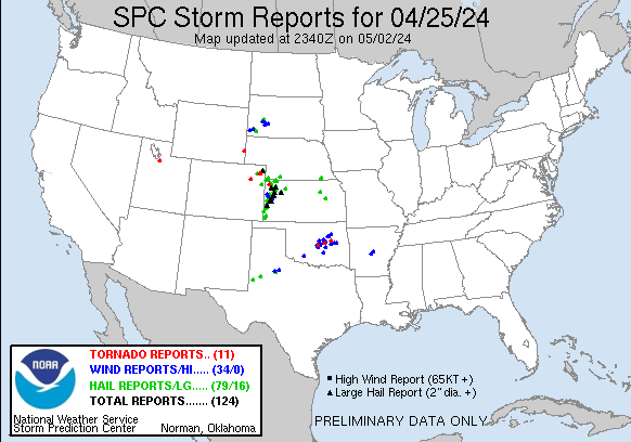