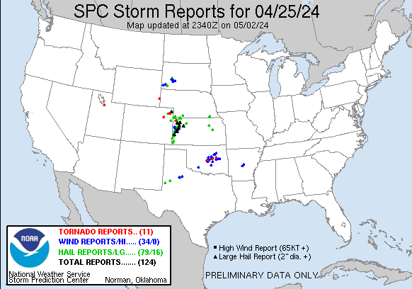
| Tornado Reports (CSV) (Raw Tornado CSV)(?) |
|---|
Time | | Location | County | State | Lat | Lon | Comments |
| 1707 | | 1 NE Herriman | Salt Lake | UT | 4053 | 11201 | [Landspout] A brief landspout was reported via numerous photos and videos. One photo in particular appears to confirm the circulation briefly touched the ground by kic (SLC) |
| 2115 | | 11 E Yoder | Goshen | WY | 4192 | 10409 | Numerous reports of a funnel cloud with occasional ground circulation between Huntley and Lyman. Separate event from earlier landspout. (CYS) |
| 2125 | | 8 WNW Elba | Washington | CO | 3997 | 10337 | WY-Comms reported a tornado south of Akron at 3:25 PM MDT. Multiple reports on social media reported a tornado SW of Akron. Webcams show tornado at 3:26 PM MDT. (BOU) |
| 2142 | | 12 SSE Wheeler | Cheyenne | KS | 3960 | 10164 | Short lived rope tornado reported with a duration of 5 minutes. Time and location via radar. (GLD) |
| 2145 | | 10 SSW Bird City | Cheyenne | KS | 3961 | 10159 | Media reported a tornado east of HWY 27 & B. Location estimated based on radar. It lasted about 2-3 minutes. (GLD) |
| 2305 | | 3 SE Clarkville | Yuma | CO | 4035 | 10257 | [Landspout] Delayed report. Multiple videos received from chasers of a broad ground circulation. Circulation does look to cross a roadway. No damage was reported. (GLD) |
| 2317 | | 5 SE Clarkville | Yuma | CO | 4033 | 10255 | [Landspout] Delayed report. Video from storm chaser of a landspout near the intersections of County Road 52 & Q. Location estimated via radar. (GLD) |
| 2329 | | 8 E Clarkville | Yuma | CO | 4040 | 10247 | [Landspout] Delayed report. Storm chaser send video of a possible landspout or tornado north of Eckley. Based on video duration of 1:35 minutes tornado likely lasted 2 (GLD) |
| 0952 | | 4 WNW Bethel Acres | Pottawatomie | OK | 3533 | 9712 | Trees and powerlines down. Likely tornado. Additional details forthcoming. Radar estimated time. (OUN) |
| 1033 | | 2 WSW Paden | Okfuskee | OK | 3550 | 9661 | A tornado developed southeast of Prague and dissipated north of Paden. It damaged a home ... snapped and uprooted trees ... and blew down power poles. (TSA) |
| 1120 | | 3 NNW Okmulgee | Okmulgee | OK | 3566 | 9598 | A tornado snapped and uprooted numerous trees ... damaged an outbuilding ... damaged the roofs of a couple homes ... and blew down power poles. (TSA) |
| Hail Reports (CSV) (Raw Hail CSV)(?) |
|---|
Time | Size | Location | County | State | Lat | Lon | Comments |
| 1637 | 100 | 5 SSE Milford | Geary | KS | 3910 | 9688 | Heavy rain falling. (TOP) |
| 1752 | 100 | 4 ESE Council Grove | Morris | KS | 3865 | 9643 | (TOP) |
| 2058 | 175 | 5 SE Wind Cave Visitors | Custer | SD | 4351 | 10341 | (UNR) |
| 2058 | 175 | 4 SE Wind Cave Visitors | Custer | SD | 4352 | 10341 | (UNR) |
| 2109 | 100 | 2 NW Buffalo Gap | Custer | SD | 4352 | 10334 | Drifts of hail (UNR) |
| 2119 | 175 | 9 E Yoder | Goshen | WY | 4194 | 10412 | (CYS) |
| 2120 | 100 | 14 SSE Bird City | Rawlins | KS | 3957 | 10140 | (GLD) |
| 2127 | 100 | 7 NE Smithwick | Fall River | SD | 4338 | 10314 | (UNR) |
| 2133 | 100 | 10 S Bird City | Cheyenne | KS | 3961 | 10156 | Delayed report via social media. Hail was found roughly 20 minutes after the storm passed. Time of LSR found via radar. (GLD) |
| 2145 | 100 | 14 NNE Saint Francis | Cheyenne | KS | 3996 | 10171 | Trained spotter reports hail up to around quarter size ... hail lasted around 15 minutes. (GLD) |
| 2145 | 100 | 8 E Yoder | Goshen | WY | 4194 | 10414 | (CYS) |
| 2147 | 175 | 4 SSW Bird City | Cheyenne | KS | 3970 | 10156 | Social media report with picture of hail stones around half dollar to golf ball in size. (GLD) |
| 2150 | 100 | 10 S Mcdonald | Rawlins | KS | 3964 | 10137 | Report with photo via social media of quarter size hail. (GLD) |
| 2200 | 150 | 5 ESE Elm Springs | Meade | SD | 4427 | 10244 | (UNR) |
| 2205 | 100 | 6 N Parks | Dundy | NE | 4012 | 10174 | The public reported 1 inch diameter hail 5N 2E of Parks. The hail is ongoing. (GLD) |
| 2210 | 150 | 2 NNW Blakeman | Rawlins | KS | 3984 | 10113 | Trained spotter reports 1 3/8 inch diameter hail. (GLD) |
| 2215 | 175 | 7 W Richfield | Morton | KS | 3725 | 10190 | Report from mPING: Golf Ball (1.75 in.). (DDC) |
| 2228 | 100 | 10 NNW Ludell | Rawlins | KS | 3997 | 10105 | Trained spotter reports estimated quarter size hail. (GLD) |
| 2230 | 250 | 5 SE Selkirk | Wichita | KS | 3843 | 10147 | Report with photo via social media of hail up to 2 1/2 inch. (GLD) |
| 2231 | 125 | 7 N Richfield | Morton | KS | 3737 | 10177 | (DDC) |
| 2235 | 175 | 13 NW Manter | Stanton | KS | 3768 | 10202 | (DDC) |
| 2236 | 150 | Ludell | Rawlins | KS | 3986 | 10096 | Trained spotter reports 1 1/2 inch hail. (GLD) |
| 2240 | 100 | Leoti | Wichita | KS | 3848 | 10136 | Time estimated via radar. (GLD) |
| 2240 | 250 | 5 NW Leoti | Wichita | KS | 3853 | 10142 | Corrects previous hail report from 5 NW Leoti. Reissued report. Report with photo via social media of hail up to 2 1/2 inch. (GLD) |
| 2240 | 175 | 5 S Russell Springs | Logan | KS | 3885 | 10117 | Time estimated via radar. (GLD) |
| 2241 | 100 | Colby | Thomas | KS | 3939 | 10105 | Corrects previous hail report from Colby. Hail was ongoing at time of report for a current duration of 5 minutes. (GLD) |
| 2242 | 100 | 1 N Colby | Thomas | KS | 3940 | 10105 | Report via social media of quarter size hail in Colby. (GLD) |
| 2243 | 125 | 10 WSW Clarkville | Yuma | CO | 4032 | 10279 | Time estimated via radar. (GLD) |
| 2244 | 250 | 2 SSE Russell Springs | Logan | KS | 3888 | 10117 | Corrects previous hail report from 2 SSE Russell Springs. Time via radar. (GLD) |
| 2244 | 150 | 3 ESE Levant | Thomas | KS | 3937 | 10113 | Hail was ongoing over I-70 at the time of the report. (GLD) |
| 2248 | 100 | 1 SSW Russell Springs | Logan | KS | 3890 | 10118 | Trained spotter reports hail ranging from pea size to quarter size. (GLD) |
| 2250 | 175 | 1 SW Russell Springs | Logan | KS | 3890 | 10118 | Trained spotter reports hail up to size of golf balls. Photos sent via social media. (GLD) |
| 2250 | 175 | Russell Springs | Logan | KS | 3891 | 10118 | Hail was ongoing at the time of the report. (GLD) |
| 2252 | 100 | Leoti | Wichita | KS | 3848 | 10136 | Report via social media with photo of quarter size hail in Leoti. (GLD) |
| 2253 | 250 | 2 SSE Russell Springs | Logan | KS | 3888 | 10117 | (GLD) |
| 2255 | 225 | Leoti | Wichita | KS | 3848 | 10136 | Delayed report via social media with photos of estimated racquet ball sized spikey hail near Leoti. (GLD) |
| 2256 | 125 | Tribune | Greeley | KS | 3847 | 10175 | Heavy quarter to half dollar sized hail was ongoing for a duration of 2 minutes. (GLD) |
| 2258 | 200 | 9 N Colby | Thomas | KS | 3952 | 10105 | Report from mPING: Hen Egg (2.00 in.). (GLD) |
| 2300 | 125 | Tribune | Greeley | KS | 3847 | 10175 | Delayed report of Public report of 1.25 inch hail in Tribune ... photo was sent in. (GLD) |
| 2300 | 250 | Russell Springs | Logan | KS | 3891 | 10118 | estimated time of report. (GLD) |
| 2300 | 250 | 3 N Russell Springs | Logan | KS | 3896 | 10118 | Trained spotter reports measured 2 1/2 inch hail. East window was broken. (GLD) |
| 2303 | 125 | Tribune | Greeley | KS | 3847 | 10175 | Trained spotter report via social media with photos and video of quarter to half dollar size hail. (GLD) |
| 2306 | 175 | 11 N Leoti | Wichita | KS | 3864 | 10136 | Ongoing quarter to golf ball sized hail. (GLD) |
| 2306 | 150 | 13 NNE Selkirk | Wichita | KS | 3865 | 10148 | Trained spotter reports inch to 1 1/2 inch hail. (GLD) |
| 2308 | 200 | 1 E Page City | Logan | KS | 3909 | 10113 | Report via social media with photo of measured hailstones ... 2 inch. (GLD) |
| 2309 | 125 | 3 SW Holyoke | Phillips | CO | 4055 | 10234 | (BOU) |
| 2310 | 100 | 7 WSW Syracuse | Hamilton | KS | 3794 | 10187 | (DDC) |
| 2310 | 100 | Sharon Springs | Wallace | KS | 3890 | 10175 | (GLD) |
| 2310 | 100 | 1 E Wallace | Wallace | KS | 3891 | 10158 | (GLD) |
| 2314 | 150 | Page City | Logan | KS | 3909 | 10115 | Report via social media with photos of ping pong ball size hail. (GLD) |
| 2316 | 100 | 2 S Brewster | Thomas | KS | 3934 | 10137 | (GLD) |
| 2319 | 150 | 2 S Brewster | Thomas | KS | 3934 | 10137 | Report from mPING: Ping Pong Ball (1.50 in.). (GLD) |
| 2320 | 175 | 3 NW Syracuse | Hamilton | KS | 3801 | 10179 | (DDC) |
| 2322 | 175 | 3 W Mingo | Thomas | KS | 3928 | 10103 | Report from mPING: Golf Ball (1.75 in.). (GLD) |
| 2327 | 125 | 4 N Syracuse | Hamilton | KS | 3804 | 10176 | Report from mPING: Half Dollar (1.25 in.). (DDC) |
| 2328 | 175 | 4 N Syracuse | Hamilton | KS | 3803 | 10176 | Report from mPING: Golf Ball (1.75 in.). (DDC) |
| 2328 | 125 | 4 SE Holyoke | Phillips | CO | 4053 | 10222 | (BOU) |
| 2330 | 250 | 5 NW Leoti | Wichita | KS | 3854 | 10142 | Corrects previous hail report from 5 NW Leoti. Social media report with pictures of hail mostly around 2 inches but at least one closer two and a half inches. (GLD) |
| 2330 | 300 | 5 NW Brewster | Sherman | KS | 3942 | 10144 | Delayed report via social media. Estimated 2-3 inch sized hail fell for roughly 30-45 minutes at the location. (GLD) |
| 2330 | 100 | 3 S Mccook | Red Willow | NE | 4016 | 10063 | Trained spotter reports pea to quarter size hail. (GLD) |
| 2330 | 175 | 10 ENE Clarkville | Yuma | CO | 4043 | 10244 | Public report with photo via social media of golf ball size hail. (GLD) |
| 2333 | 200 | 10 N Syracuse | Hamilton | KS | 3813 | 10175 | 2 inch hail reported. (DDC) |
| 2340 | 250 | 5 NW Leoti | Wichita | KS | 3853 | 10142 | Reissued report. Report with photo via social media of hail up to 2 1/2 inch. (GLD) |
| 2345 | 175 | 16 N Syracuse | Hamilton | KS | 3821 | 10173 | (DDC) |
| 2345 | 250 | Russell Springs | Logan | KS | 3891 | 10118 | Corrects previous hail report from Russell Springs. estimated time of report. (GLD) |
| 2354 | 200 | 3 E Holyoke | Phillips | CO | 4058 | 10225 | (BOU) |
| 2355 | 175 | 3 N Syracuse | Hamilton | KS | 3803 | 10175 | Golf ball sized hail reported. (DDC) |
| 0120 | 175 | Grainfield | Gove | KS | 3911 | 10047 | Public report via social media of hail quarter size to a few golf ball size. (GLD) |
| 0120 | 200 | Grainfield | Gove | KS | 3912 | 10048 | Ping pong to egg sized hail observed in Grainfield. (GLD) |
| 0122 | 175 | Grainfield | Gove | KS | 3912 | 10047 | Emergency management relays reports of hail up to the size of golf balls. (GLD) |
| 0127 | 100 | 7 S Idalia | Yuma | CO | 3959 | 10231 | Trained spotter reports dime to quarter size hail. (GLD) |
| 0152 | 100 | Odell | Gage | NE | 4005 | 9680 | Trained spotter estimates quarter sized hail at the Odell Fire Hall. (OAX) |
| 0155 | 175 | 5 N Odell | Gage | NE | 4012 | 9680 | Trained spotter received a photo from family 5 miles north of Odell showing hail ranging from quarter to golf ball size. (OAX) |
| 0158 | 175 | Morland | Graham | KS | 3935 | 10007 | Report via social media (X) of quarter to intermediate golf ball size hail near Morland. (GLD) |
| 0210 | 100 | 14 NW Saint Francis | Cheyenne | KS | 3993 | 10197 | Delayed report. Quarter sized hail with 90 0round coverage and torrential rainfall. (GLD) |
| 0258 | 150 | 4 N Seminole | Gaines | TX | 3278 | 10265 | Media relayed reports of Ping Pong ball sized hail north of Seminole. (MAF) |
| 0301 | 100 | 6 N Seminole | Gaines | TX | 3281 | 10265 | Seminole Fire Dept reports Quarter sied hail 6 mi north of Seminole on HWY 385. (MAF) |
| 0407 | 125 | 11 E Union | Lynn | TX | 3302 | 10203 | (LUB) |
| 0634 | 175 | 4 W Girard | Kent | TX | 3336 | 10073 | (LUB) |
| Wind Reports (CSV) (Raw Wind CSV)(?) |
|---|
Time | Speed | Location | County | State | Lat | Lon | Comments |
| 1342 | UNK | 2 SSW Sherwood Estates | Saline | AR | 3459 | 9254 | mPing report of large tree limbs blown down and shingles blown off of a roof. (LZK) |
| 1350 | UNK | 3 WSW Little Rock | Pulaski | AR | 3473 | 9234 | A large tree was downed at the Arkansas Cooperative Extension. (LZK) |
| 2037 | 58 | 11 W Hot Springs | Fall River | SD | 4343 | 10369 | (UNR) |
| 2058 | 60 | 5 SE Wind Cave Visitors | Custer | SD | 4351 | 10341 | (UNR) |
| 2058 | 60 | 4 SE Wind Cave Visitors | Custer | SD | 4352 | 10341 | (UNR) |
| 2224 | 59 | 8 S Wall | Pennington | SD | 4388 | 10224 | (UNR) |
| 2227 | 60 | Wall | Pennington | SD | 4399 | 10224 | (UNR) |
| 2232 | 59 | 3 NW Wasta | Pennington | SD | 4410 | 10250 | (UNR) |
| 2248 | 63 | 6 W Cottonwood | Jackson | SD | 4397 | 10201 | (UNR) |
| 2310 | 60 | Sharon Springs | Wallace | KS | 3890 | 10175 | (GLD) |
| 2313 | 60 | 8 N Marienthal | Wichita | KS | 3860 | 10123 | (GLD) |
| 2314 | 70 | 9 SSE Sharon Springs | Wallace | KS | 3877 | 10168 | C6099 in SE Wallace county recorded a gust of 70 MPH. (GLD) |
| 0517 | 67 | 1 W Spur | Dickens | TX | 3348 | 10088 | (LUB) |
| 0545 | 61 | 10 WSW Guthrie | King | TX | 3357 | 10048 | (LUB) |
| 0546 | 65 | 10 WSW Guthrie | King | TX | 3357 | 10048 | (LUB) |
| 0830 | UNK | 4 E Lawton | Comanche | OK | 3461 | 9833 | Power pole snapped in half. Radar estimated time. (OUN) |
| 0945 | UNK | 4 NW Stella | Cleveland | OK | 3536 | 9726 | Social media image showing multiple large tree limbs blown down. Radar estimated time. (OUN) |
| 0950 | UNK | 3 E Lake Thunderbird | Cleveland | OK | 3523 | 9718 | Powerline down. Time is radar estimated. (OUN) |
| 1003 | UNK | Dale | Pottawatomie | OK | 3539 | 9705 | Relayed image showing the roof removed from a mobile home. Radar estimated time. (OUN) |
| 1010 | 63 | 3 NNW Shawnee | Pottawatomie | OK | 3536 | 9695 | Shawnee (SHAW) Mesonet. (OUN) |
| 1010 | UNK | 3 NW Shawnee | Pottawatomie | OK | 3536 | 9695 | Relayed image showing light roof damage (panels removed) to a home. Radar estimated time. (OUN) |
| 1010 | UNK | Wellston | Lincoln | OK | 3569 | 9707 | Powerlines down. Radar estimated time. (OUN) |
| 1015 | UNK | 3 NW Shawnee | Pottawatomie | OK | 3536 | 9697 | Report of box truck overturned. (OUN) |
| 1030 | UNK | 2 NNE Centerview | Pottawatomie | OK | 3546 | 9666 | Trees and powerlines down along with minor damage to a home. Radar estimated time. (OUN) |
| 1040 | UNK | 1 E Stroud | Lincoln | OK | 3575 | 9665 | Roof damage to an apartment building. Radar estimated time. (OUN) |
| 1048 | UNK | 6 NNE Paden | Okfuskee | OK | 3559 | 9652 | Several large tree limbs downed. (TSA) |
| 1050 | UNK | 5 N Wewoka | Seminole | OK | 3522 | 9649 | Trees down. Radar estimated time. (OUN) |
| 1059 | 61 | 1 WSW Ada | Pontotoc | OK | 3477 | 9667 | Measured via handheld anemometer. (OUN) |
| 1109 | UNK | 5 W Kellyville | Creek | OK | 3595 | 9631 | Large tree and a number of large limbs down near Heyburn Laske RV Park. (TSA) |
| 1117 | 60 | Kellyville | Creek | OK | 3595 | 9621 | Along I-44. (TSA) |
| 1122 | 60 | Henryetta | Okmulgee | OK | 3544 | 9598 | (TSA) |
| 1130 | 60 | 5 NW Jenks | Tulsa | OK | 3607 | 9603 | (TSA) |
| 1136 | 60 | Hitchita | McIntosh | OK | 3552 | 9575 | (TSA) |
| 1156 | 63 | Checotah | McIntosh | OK | 3547 | 9552 | (TSA) |


 @NWSSPC